Sunday, December 31, 2017

12/31- With Horrifying Hurricanes, Brutal Blizzards, and Record Temperatures, 2017 Was One for the Ages

Good Sunday all-

Happy new year! We will be welcoming 2018 with a very close run on the models. We are right on the fringe right now of a snowstorm for this upcoming Thursday. In fact...the difference of about 100 miles will determine if we get nothing...a glancing blow...or a blizzard that only happens in our area about once every century or so. Right now, I favor choice 'B'- which would still be a major snowstorm for our area on the order of 8-16" (so imagine what choice 'C' is- trust me, you don't want to know). Regardless, the cold remains firmly in place and if you intend to visit Times Square tonight, BUNDLE UP- this will likely be the second coldest ball drop...ever recorded with temperatures in the high single digits. Youch! Stay warm!!! Now for a look back on the incredible, record breaking year that 2017 was for us in Connecticut and across the entire western Atlantic.


January was a month that featured well above average temperatures, and was surprisingly snow free, with the exception of Winter Storm Breanna, which dropped a general 5-8" of snow on the state on the 8th. This continued the recent trend of dry and relatively snow free January's, the third year in a row that one or fewer named storms occurred during the month. Little did we know the winter had just begun.

February was the tale of two months, with two significant snowstorms, but also 70 degree temperatures at the end of the month. For most, the most significant snowstorm of the winter was Blizzard Chris on the 9th, which was followed by Winter Storm Diana just three days later on the 12th. After that though, the temperatures swung in the extreme, with several days in the last two weeks of the month well into the 60s and even reaching the 70s on several occasions, leaving many to believe that winter was over, which proved to be extremely premature.

March was an exceptionally cold month, with temperatures nearly 6 degrees below average! To add insult to injury, March also featured well above average snowfall, with Blizzard Eugene on March 14 delivering 1-2ft of snow to the entire region. There was no true warmup at any time in the month, and at times it made you wonder if spring really was around the corner. In fact, for just the 4th time on record, March was actually colder than February!

April was decent, but not all that unusual. The most notable thing about the month is that the year and a half long drought finally came to an end with substantial rains falling through the month on several different occasions. Temperatures were roughly seasonable in a relatively unremarkable month

May certainly had its' ups (high temperatures in the 90s several times mid-month) and downs (several days with rain falling heavily all day). In the end, however, the most notable weather event of the month was the severe weather outbreak on the 31st, which featured large hail, picturesque shelf clouds, and a tornado warning for Fairfield/Litchfield County. Although no tornado was recorded, it still was quite the evening!

June was a tale of two extremes. The first two weeks were exceptionally cool, including one of the coldest June days on record with highs in the low 50s and lows generally in the low 40s with a few places even in the upper 30s(!) in places on the 6th. The second part, however, featured far more typical weather, with several days of thunderstorms and summery heat and humidity. The precipitation wound up very close to the average.

July was a pretty typical July here in Connecticut, with temperatures primarily fluctuating between 75 and 95, with very few days outside of those parameters. Two heat waves occurred during the month, which is not at all unusual. Severe weather was rather uncommon, though the microburst in Derby on July 13 did cause a fair amount of damage in southwestern New Haven county.

August was not overly noteworthy in Connecticut, with temperatures only slightly below average. The most notable fact regarding the month is that somehow there were only two 90 degree days in Hartford, which is exceptionally difficult to do in August. Precipitation was well below average for the month, coming up at a total of 2.66". Of course, August will be remembered most by the weather world for the disaster that Hurricane Harvey and its' subsequent extreme rains caused in Texas, leading to a long-thought unbreakable record falling, establishing itself as the costliest natural disaster in US history.

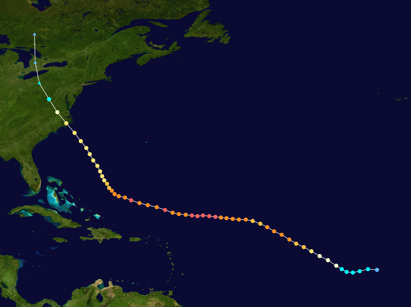
September belonged to the hurricanes, although we managed to dodge a few bullets locally. Two category 5 hurricanes formed in the month, marking the first time since 2007 a season has had multiple storms reach the highest intensity. To make matters worse, both of these storms (Irma and Maria) made landfalls at category 4 intensity, clobbering Florida and Puerto Rico. Both of these storms will be remembered for a very long time indeed, and surely will join Harvey on the retired name list. The other notable hurricane, Jose, made a very serious run at our area, even prompting Tropical Storm watches for a brief period before ultimately passing safely to the southeast of Cape Cod. Temperatures locally were far above normal, with an average of 78.4 degrees. The dryness also continued, with a rainfall deficit of over an inch, briefly returning parts of the state to drought conditions. This would be wiped clear, however, in that wild last week of October.

October was an extremely warm month, and it seemed like it would be mainly dry until the two major storms clobbered the region on the 24th and 29th, both dumping upwards of 5" of rain on our area and completely wiping out the drought, and causing an October rainfall total nearly double the average. The warmest October on record for many locations, including both Hartford and Bridgeport, ended with a bang to be sure! Most notably, however, the October 29th curse struck again, with a massive coastal storm with influence from the remnants of Tropical Storm Philippe clobbering the region with winds gusting upwards of hurricane force across the state, doing a great deal of damage and causing nearly 200,000 power outages across the state, in some cases lasting for several days. Definitely one to remember!

November was dryer than normal for sure, but also much, much colder than normal. Overall, BDL finished the month with an average temperature of 42 degrees, which is two degrees below normal. There was 1.04" of precipitation, which is about 2" below normal as well for the month. The most notable part of the time period was the aforementioned cold, especially in the final two weeks of the month, which saw temperatures plunge into the teens at times. Most also experienced their first snow of the 2017-18 winter, although it was by no means substantial, with only a trace falling in Hartford. That would change in a big way for December, however.

Finally, December was the first truly wintry December in quite some time, and boy was it ever. Temperatures were far below average (exactly how far remains to be seen- I'll have final numbers tomorrow), and was extremely snowy as well. At my house in Naugatuck, we recieved 16" of snow for the month, which is only slightly less than half of the average annual snowfall. With more snow possible on Thursday (the current Euro proposes one to one and a half feet), this will only increase, and the pattern for January looks pretty good for snow, with the exception of the week from after Thursday until the following weekend or so (and even then, some snow certainly could fall). To put this in perspective, should 16" fall in the four months where it is realistic (Dec-Mar), we would get 64" of snow on the year, which is about 15" above the average annual snowfall for the region...and is close to an all time top 10 year. In general though, remember that our snowiest month of the year is actually February.


Wishing you a very, very happy 2018! May it bring peace, joy, and wonderful new memories to all the world.


Wednesday, December 27, 2017

12/27- One of the Coldest Runs in Recorded History on the Way

Good Wednesday all-

I hope everyone had a wonderful Christmas and was able to enjoy the time spent with friends and family.

Among the many stories of the next week or so, one that will take the most time to talk about is the cold weather. In fact, the potential exists for this to be the coldest ten day stretch ever recorded at BDL, as we may not see temperatures hit 20 degrees not just today...but until well into 2018. Yak! Well, what can you do except shake your head and keep the heat on and stay warm. For what it's worth, the overnight lows look to feature many nights with temperatures close to or even below zero degrees. Yeah, so not good. Bundle up this week and next! Another storm threat appears to lie around Friday 1/5. Which, go figure, I have a flight on that day to Austin, TX to attend the meteorology conference there from the 8th to the 11th...so that's a high-risk forecast for me personally too!

There also remains a snow threat for the morning of New Year's Eve. Of our two major models, one has consistently suggested a major snowstorm for New England (the Euro) while another (the GFS) has no storm anywhere within 1000 miles. The Canadian model is closer to the Euro, forecasting a general 4 to 8" of snow lasting from about 9 PM on Saturday to 3 PM on NYE. Lovely. That's extremely unhelpful to say the least, so we have to watch this very closely over the next few days as we begin to get a better picture.


Monday, December 25, 2017

12/25- Gee, thanks Computer

Greetings-

I'm baack- sorry it took so long, but this time it wasn't nmy fault- my computer underwent a fatal hard drive error about two weeks ago and thus I have been unable to update.

That said, I'm back! And I'm glad to be- I just got a new, fancy laptop for Christmas and I'm loving it!

Now, the weather is very festive, with a moderate amount of snow having fallen across most of Connecticut this morning. In Naugatuck, it seems I have picked up roughly 3", which brings my annual snowfall up to 15"- about one third of the average annual snowfall in the last two weeks, beginning with Winter Storm Ali dropping 7" on me on December 10. Since then, a series of 2 or 3" snowfalls has improved my totals up dramatically.

Now, onto the more important part of the weather- a frigid (and I mean frigid) week ahead, featuring temperatures of 15 or so for highs and near to possibly sub-zero lows by the middle of the week. The next chance for snow is next weekend, and the threat appears to be pretty substantial, so we certainly have to keep a close eye on it as we approach new year's eve. For what it's worth, January looks to feature below average temperatures with at least average amounts of snowfall.

I wish everyone the very merriest of Christmases and hope you enjoy the last week of 2017!

Thursday, November 30, 2017

11.30- Goodbye Hurricane Season, Hello Winter!

Good Thursday all-

Sorry for not updating lately, but there was nothing to talk about. Homework and school have been really tough this semester and I apologize for not having updated nearly as much as I have in the past. For far more regular updates, I highly recommend that you follow me on twitter- @stevectweather.

No storms are on the immediate horizon at this time, but certainly the odds look to increase by next weekend. Obviously that's still way, way out there and things will change, but the pattern looks to be locked and loaded for about a month and a half once we get through a week or so.

Thus, I'll do this for my winter snowfall predictions as we head into meteorological winter

BDL: 78.5"- this total would be 33" above average and the 7th snowiest winter on record

BDR: 56.5"

I'm going with these bullish forecasts because of the pattern setup. The winters that compare most to the current pattern are 2005-2006, which featured 69.9"...and 2010-11 which had 86.4" (and is the second snowiest on record). Thus, I'll go with a blend of the two results and obtain this value. Even if the 05-06 result verifies, we'd be knocking at the door of a top 10 year, so the outlook is promising for snow lovers.

Today...November 30, 2017...marks the end of what has been a downright historic and devastating hurricane season that will be remembered forever alongside the other great hurricane seasons of 1995, 2004, and 2005. The final totals for this hyperactive year were (barring some December weirdness) 17 named storms...10 hurricanes...6  major hurricanes...and 2 category 5's (this is just the 6th year ever recorded that this has happened). Also, Jose was literally 1mph shy of cat 5 intensity as well, so we were extremely close to having this become just the second year ever to have three category 5 storms.

Needless to say, the most memorable storms this year were Harvey, Irma, and Maria. All three of these names will undoubtedly be retired and replaced by the time this list is reused six years from now in the 2023 Atlantic Hurricane Season. Here in CT, we were impacted indirectly by Tropical Storm Philippe, which ended up producing a powerful hurricane-type storm over CT and did a massive amount of damage on October 29.

Many records were set this season including: Most damaging season on record by USD ($369 billion), 2nd longest time consecutively spent as a category 5 hurricane (Irma, 3 days), strongest hurricane over the open Atlantic (Irma, 914mb), strongest April tropical cyclone (Arlene, 990mb), 2nd highest windspeed in the Atlantic basin in a hurricane (Irma, 185mph), fastest time from a tropical depression to a category 5 hurricane (Maria, 30 hours), tied for the 9th most active season on record by named storms (17), longest time a hurricane has had sustained winds greater than or equal to 185 mph (Irma, 37 hours), and the big one that many (myself included) thought would never fall- costliest tropical cyclone on record: Harvey ($198 billion), passing Katrina by a wide margin.

What a year. Let's hope 2018 is significantly less active. As for my preseason prediction review, I went 15-7-4...that actually was pretty close! I'll take it!

Today we say goodbye to meteorological fall and hello to winter. Have fun with the snow. I'll update here when a significant storm is on the horizon. Until then!

Image result for goodbye autumn


Saturday, November 4, 2017

11/4- Update, Cold Weather Incoming

Good Saturday everyone-

The weather is taking a turn for the chillier this week, as we will actually be below average by a fairly significant margin for most of the next 7 days. Highs likely will be primarily in the 50s, but next weekend looks like it could feature highs as low as the upper 30s! Snow is possible as well around that timeframe, but it would be a few "mood flakes" in all likelihood and nothing accumulating. There is a small chance of something more significant, but the odds of 2"+ of snow are something like 5% at the current time, which is extremely low. It's just tough to do that in early November, but it's a sign of the times for sure.

Remember to set your clocks back tonight!

Thursday, October 26, 2017

10/26- The Curse of October 29th Strikes Again- MAJOR Storm Likely

Good evening everyone-

I'm here with an update on what is going to be a massive and potentially damaging storm to Connecticut on Sunday evening.

This has come up very quickly on models- as recently as 36 hours ago, there was no indication of this, but now the system is seemingly getting more significant with each passing run.

Right now, we have two distinct model camps- the GFS/Canadian model and the European/UK model. Based on the fact that this is a very similar setup to what delivered Hurricane Sandy to New Jersey...and the success of the European model in the past...I'm more inclined to believe the more western camp of models. Should the eastern models varify (and most meteorologists, including myself, believe this to be rather unlikely)--you can cut all the wind values I am about to post roughly in half. I am fairly comfortable with my forecast though- the GFS was in the western camp earlier today, and the 18z run is notorious for producing garbage solutions, so here we go.

Timing: Rain should arrive sometime early Sunday afternoon and last for roughly a full day, ending early to mid-afternoon on Monday.

MAJOR THREATS

1. Heavy Rain- This is going to happen even if the eastern outliers are correct. Extremely intense rainfall is going to happen Sunday night, with 3-6" of rain widespread...with locally higher amounts possible. The ground is already saturated thanks to the biggest rainstorm CT has seen in six years Tuesday...but this may surpass it too!

2. Strong to Damaging Wind- This is highly, highly dependent on track. If it goes east, as I was saying, you can cut these numbers by one third to one half. For now, I think most areas on the shoreline will experience near or above Tropical Storm conditions, or a sustained wind of 40mph, for at least a few hours. Inland, it's likely to be more in the 25-35mph range as a general rule. The real fun, however, is in the gusts. Computer models have been massively aggressive on these, especially the European run this afternoon (which puts the storm over NYC). Using a general compromise of the data I've been looking at, I would expect peak gusts to be between 45 and 65mph. It wouldn't shock me if a shoreline town hit 70mph. The Euro is significantly more agressive than this, showing hurricane force gusts for more than half of the entire state, which...yeah that would be pretty darn bad. For reference, the peak wind gust in CT during Hurricane Irene was 65mph, and the peak wind gust during Sandy in our state was 85mph. Thus...something between the two seems most likely at the moment.

3. Storm Surge- Again, this is highly dependent on the exact track our system takes, but if it passes to our west ala the Euro, water would be given the chance to pile into LIS from east to west, ultimately causing a fairly significant amount of coastal flooding and damage. Fortunately, the difference is that this storm is NOT coming at an astronomical high tide by any stretch. Regardless of track though, thanks to the weaker system and smaller size, this will NOT BE ANYWHERE NEAR AS BAD AS WHAT WAS EXPERIENCED IN SANDY/IRENE UNLESS SOMETHING MAJOR CHANGES.

In summary, what do I think the actual impact will be perceived as? Ultimately, a Euro-type storm would produce Sandy/Irene type impacts with massive power outages, trees down, and coastal flooding and erosion- Cosey Beach are you listening? One very trustworthy local meteorologist put it best this afternoon. He was asked on twitter "Will this be as bad as Sandy?". His response was, essentially, as a whole, not even close. In individual local areas though...yes, it could be. I couldn't agree more. This storm will not have the 1000 mile windfield or the devastating storm surge we saw five years ago on the Jersey/NYC/CT shoreline. That said, we look to be perfectly in the windfield, set up for some coastal flooding, and get another half foot of rain into an already saturated ground. The damage could be significant. My advice...prepare for this system as you would prepare for a hurricane. There is a scenario in which you could be out of power for several days...and you'd always rather be safe than sorry.

I'll have a full update tomorrow morning with the latest on this major, major storm.
^^^The 12z Euro putting a storm with the minimum pressure equivalent of a category 1 hurricane directly into Manhattan. This is the worst possible outcome for tropical systems in CT, and would result in a historic event, with extreme power outages and significant damage.


^^^18z GFS, much farther east than the Euro, however the run before this showed...

^^^12z GFS, showing nearly the exact same thing as the Euro.

Which one is right? Take your pick. The worst of the three would be the Euro- the 12z GFS is actually "too direct" of a hit for extreme wind in CT, as the strongest wind would be over Cape Cod and eastern MA if it verified.


Friday, October 20, 2017

10/20- Major Rainstorm for Tuesday

Happy Friday everyone-

There is no change to the forecast I gave earlier this week for the next three days. However, there is one issue in the forecast now- and that is Tuesday. It truly looks like a total washout starting mid afternoon, with heavy rain pretty much all day thanks to a low that will develop along a cold front and ride the coastline all the way up into southern New England. As a general rule, 0.5 to 1.5 inches of rain can be expected, with highs then proceeding to go from the mid 70s to the low 60s- quite a significant dropoff and near the average temperature for this time of year.


^^A very wet Tuesday afternoon and evening

If the World Series is played at Yankee Stadium next weekend, the weather looks dry with average temperatures- generally the mid to upper 50s around gametime. A early look at Halloween suggests fiendishly below average temperatures with highs in the upper 40s or low 50s with dry conditions.

Monday, October 16, 2017

10/16- Beautiful Week

Good Monday all-

Not much to talk about in the weather world today- although Hurricane Ophelia is hitting Ireland this morning...but we're dry and sunny until, well...a really long time from now. In fact, I expect sunny conditions and slightly above average temperatures until Saturday...well except tomorrow, which will feature temperatures stuck in the mid-50s through the entire afternoon. Otherwise, I have nothing to talk about- I just wanted to post something here- so get out there and enjoy a wonderful October week!

Monday, October 9, 2017

10/9- Remnants of Nate

Greetings all-

Apologies for my extended absence from this blog. One of my dogs was eaten by a coyote last weekend and I was dealing with that for quite some time.

I'm back now though, but unfortunately I bring Hurricane Nate's remnants with me, which means that pouring rain is expected for the vast majority of the day today. This could impact the baseball games scheduled for this afternoon at Fenway Park and Yankee Stadium, and could be highly significant as these are playoff games but we will have to wait and see how that plays out. Regardless, tomorrow looks much better, with highs generally in the upper 70s and moderate humidity...but a strong cold front will move through in the late afternoon tomorrow. This will come through dry, but the temperatures will be a good 10-15 degrees cooler on Wednesday with a risk of showers in the afternoon thanks to a frontal system stalled just to our south. The clouds will stick around for Thursday- though I think we get through most of the day dry, but showers are likely Thursday morning. We finally clear things out completely for Friday, and then we get back to the warmer weather Saturday.

Long range models suggest a major cold snap in roughly two weeks. Be ready- this could feature the first flakes of '17-'18.

Tuesday, September 26, 2017

9/26- Fall FINALLY- Very Nice Week

Good Tuesday evening--

What a great few days it has been...at least if you like heat. Highs today reached 90 for the third straight day for a rare late September heat wave here in Connecticut, and tomorrow we will come close again (but likely fall a few degrees short). By the afternoon though, clouds will be on the increase and a strong cold front will push into southern New England, with some isolated showers possible, especially in the late afternoon. The precip will come to an end by Thursday morning, but it will have knocked the temperatures down nearly 15 degrees- highs on Thursday will be in the low 70s and by the weekend, highs will be in the 60s...which, although it sounds cold, is actually very close to average for this time of year. That's a fair tradeoff though- this cold front also saves the northeast from Hurricane Maria, which will be pushed out to our southeast. We do warm things up a bit next week...but only into the low 70s, which is not at all unusual. It would not surprise me if tomorrow is the last 80 degree day of 2017. We will see of course- it's always possible to get one somewhere further down the line- but it is way harder as we approach the fall season.

Also noteworthy is that today, thanks to hurricanes Maria and Lee, we have just broken the all-time record for the most active month in the history of the Atlantic basin...surpassing September of 2005. This month featured Irma (cat 5), Jose (very high end cat 4- 1mph away from cat 5), Katia (cat. 2), Lee (cat 3) and Maria (cat 4). That's pretty impressive to say the least!

Friday, September 22, 2017

9/22- Fall Begins Very Warm, MUCH colder next week

HAPPY FRIDAY-

Trust me, nobody's happier this one is here than me. I had three papers and a test last week, so my apologies for not posting.

Jose is gone, and behind it we have summer-like weather on this day as we say goodbye to summer. 4:02 PM today is the autumnal equinox. The weather will be incredible for the next few days though- temperatures will be in the 80s to, if you can believe it, near 90(!!!) tomorrow. We do, however, finally see the temperatures nose-dive around next weekend. Some models actually suggest some days with highs in the 40s a week from Tuesday. That may not be particularly likely, but that goes to show exactly how much we cool off. If you're looking the bright spot, consider this- this cold outbreak 1- shows that fall truly is here and more importantly 2- keeps New England from getting a catastrophic hurricane next week as it will force Maria out to sea to the southeast.

All in all, hop on the temperature roller coaster and enjoy your ride! As for precipitation, the wettest day of the next 7 appears to be Friday as the Maria-deflecting cold front moves into the region.

Image result for goodbye summer
It's been fun, summer- see you in June!

Image result for happy fall
The season of pumpkins, turkeys, beautiful leaves, and first flakes is here. Happy fall! May it bring you as many fond memories as possible!

Friday, September 15, 2017

9/15- SEVERE STORM WATCH- This Way, Jose!

Happy FRIDAY everyone!

Tropical Storm Jose has taken another jog to the west overnight...and the computer models are now far closer to the shore than they were yesterday morning. A plurality of model runs are now forecasting a direct hit in a mere four days. As a result...I have to issue a SEVERE STORM WATCH for Jose, with tropical storm conditions likely...and hurricane conditions possible...on Tuesday afternoon and early Wednesday morning.

Here are some good comparisons to use:

GFS model-

Yesterday:

^^^0z GFS from Thursday morning. Jose is way out to sea

Now:

^^^0z GFS from this morning showing a direct hit on the region

OUCH. The first would have been nothing but some surf, but the second introduces hurricane conditions to Connecticut for the first time in 22 years.


^^Spaghetti models...they are much, much further west than yesterday.

All in all, I suggest to prepare for TROPICAL STORM CONDITIONS TUESDAY AFTERNOON. It is possible we get hurricane conditions, and I will certainly blog if the most likely outcome goes from missing by about 25-50 miles to a direct landfall on our area.

Also, if you live on the shoreline, Wednesday is the new moon. That's just asking for a major disaster when a hurricane is nearby...so please be extra careful.

Thursday, September 14, 2017

9/14- All Eyes To the Atlantic

Good Thursday all-

Well, I am going to mostly focus this post in one place- Hurricane Jose- as it appears to be coming closer and closer with each model run. A blocking high to our east is trying to develop, and how strong it is is going to make all the difference in the world. Any impact from Jose would be Tuesday afternoon into Wednesday

At the minimum? Expect some rain and brief gusty wind, along with elevated surf

At the maximum? I cannot rule out a directly landfalling category 2 hurricane.

That said, as always, the actual outcome will likely fall somewhere between these two extremes. I will be watching closely though. If I lived on Cape Cod...I would be VERY concerned right about now. The last time a hurricane made landfall anywhere in New England was Bob in '91...and this has probably about a 35% chance of doing so.

If I had to put a number on it right now, I would say the odds of seeing actual hurricane conditions in Connecticut is about 15-20%. Not very likely. The odds of tropical storm conditions? Probably about 50-50...which is very high.

All in all, pay very, very close attention to the forecast as time goes on. Models are constantly coming in and we will see exactly what surprises await in the next few days with this (and some surely do).


Wednesday, September 13, 2017

9/13- No Way, Jose!

Good Tuesday all-

Sorry for the late posting but it's my dog's fault- he literally ate the power cord of my laptop, rendering it unusable for several days. I'm back now, and we have a fair amount to discuss.

First off, the next few days do not look all that great thanks to the remnant moisture of Hurricane Irma and its' interaction with a slow moving cold front off to our west. We will very likely be dealing with shower activity each day between now and Saturday...with tomorrow and Friday looking the wettest. Sunday should be dry, fortunately, with highs near 80 and sunshine likely.

Beyond that though, all eyes shift to one of the most bizarre hurricanes in recent memory. Hurricane Jose has completed a 360 degree loop in the Atlantic, and is expected to move west and then slowly north along the east coast. The problem is that it will then likely slow down again and try to move out to sea, but a blocking high could be in place. If that is the case, it could loop it back into the eastern seaboard somewhere between North Carolina and southern New England. This is a highly complex and strange forecast, so we will have to keep our eyes on it for sure.

Have a great Hump Day!

Friday, September 1, 2017

9/1- As September Begins, All Eyes on Irma

HAPPY FRIDAY EVERYONE-

What a nice morning we have- and in fact we are going to be very fortunate in that this Labor Day weekend will be beautiful for two-thirds of it. The only trouble spot is Sunday...and that is in association with the remnants of Hurricane Harvey...but it won't be a big deal whatsoever- just some rain and showers on Sunday. Otherwise...we can expect generally partly sunny conditions and temperatures in the 70s from now until Tuesday, when temperatures begin to climb into the 80s.

Of course, the big story today in the weather world remains Hurricane Irma, which is now a category 3 major hurricane. We have to wait and see, but many models have decided to take this into New England as a category 3 or higher hurricane...so this bears close watching as we go through the next week. Any impact is about 9 or 10 days away though...so there certainly is time for changes- and they WILL happen.                    

Thursday, August 31, 2017

8/31- Farewell August!

Good Thursday all-

Watching the tropics is the big story of the day today. Some thunderstorms are possible here in CT this afternoon- not severe by any means, but don't be shocked by an isolated rumble or two as we head through the afternoon and evening hours. The weekend's big stories will be 1- the remnants of Hurricane Harvey on Sunday, but that shouldn't be too big of a deal...2- A beautiful Labor Day...and 3- Near record lows tomorrow night- we will likely be in the mid 40s, and the record low of 43 is reachable for the Hartford area...we shall see.

Unfortunately, everything may take a backseat over the coming days to what will be Major Hurricane Irma and her progress across the Atlantic basin. The storm has an eye feature this morning and will almost certainly attain hurricane status at 11 AM. Models are extremely aggressive on developing this one, and many make this a category 5 either in or just north of the Caribbean. My thoughts regarding the path have not changed since yesterday, but I am concerned that a high pressure system in the central Atlantic could block a recurve. A decent analog to start with would be 2003's Hurricane Isabel, which obtained Category 5 intensity north of the Caribbean before clobbering North Carolina as a category 2 after it traveled the entire Atlantic ocean.


^^^Path of Isabel 2003. Irma could take a similar path at a similar intensity

That said, don't pay it much heed for now- any impacts on our weather here in CT would be well over a week away. In five days, it will be approaching the Antilles. Plenty of time to watch this one, and I will be doing so.

Lastly, I have created a twitter account, my handle is @stevectweather. Feel free to follow me there for more Irma stuff and general weather stuff, especially as we head into the snowy season here in New England.

Wednesday, August 30, 2017

8/30- Looking Back on Harvey and ahead to Irma

Good Wednesday all-

What a crazy week of weather it has been, with the most important hurricane in years striking Texas. This is one that will go down in the record books as the highest rainfall total ever produced in the lower 48 by a tropical system.with 52" of rain falling on Houston. The current death toll of 15 is likely to rise, perhaps dramatically, over the next few days. It just goes to show that wind is not the be all end all of these things- far more damage was done by the water than the cat 4 winds.

The future however does not look bright for Houston right now as a new tropical system is likely to develop in the Gulf next week and generally move towards the area...ugh...so keep them in your thoughts. One model...the GFS...suggests another 2ft of rain next week. Ouch.

On another note, we have to keep an eye on what will likely be Major Hurricane Irma in the coming days. The system is currently near Cape Verde, and it will be moving generally NW and then SW over the coming week or so. The big question is what happens when it gets to the area just north of the Antilles...and that is anyone's guess, although the pattern does appear favorable for a US impact at some point down the road. It could be anywhere between south Texas and Maine right now though...so we'll have to wait and see.

Locally, we can expect this good stretch of weather to continue for a while more, with the main blip in the forecast being the remnants of Hurricane Harvey this weekend. Labor Day looks dry for now, which is perfect for those last barbecues as we get ready to head into the fall season. Temperatures should be in the mid 70s and mid 80s over the next week or so. Beyond that, all eyes turn to Irma.

The Baja Peninsula of Mexico will likely be impacted by a tropical storm tonight as well, which would be named Lidia.


Tuesday, August 29, 2017

ANNOUNCEMENT

Greetings-

My apologies for my extended absences from this blog this summer. Between travelling & general craziness, I have not really had much time to do it.

The good news is-

I AM BACK. UPDATES WILL RESUME AS NORMAL BEGINNING TOMORROW, 8/30/17, AND WILL BE ON WEEKDAYS THROUGH THE FORESEEABLE FUTURE.

If you know other people who read this blog, please let them know about this as I am sure not that many people check every day anymore.

Thank you for sticking with me.

Of course, my prayers go out to the victims of Hurricane Harvey in Houston. I will absolutely have a larger discussion on this storm tomorrow morning.

Friday, August 4, 2017

8/4- Hot and Humid Again

Happy Friday everyone-

Today is going to be pretty similar to the last several in that we can expect temperatures to be in the upper 80s with some afternoon thunderstorms. Having said that, of course, I would be remiss to not mention the storms on Tuesday- wasn't that impressive?! I had some large hail at my home in Naugatuck, and it was probably the most impressive storm that I have been in regarding hail. As for this upcoming weekend, it appears pretty good, with some showers and storms likely to impact our area tomorrow afternoon, but high temperatures should be in the low 80s for almost all of the next 7 days...with the exception being Monday, which looks significantly cloudier and cooler- temps will likely be stuck in the 70s with a chance of showers in the afternoon.

The major story right now in the weather world is the tropics. A couple of systems are posing serious development risks. One is in the Caribbean, and another is near Cape Verde. What is interesting is the models disagree dramatically about the one near Cape Verde- the one more likely to develop, but both are fairly likely. Here's the difference...

^^6z GFS showing a massive hurricane near the Bahamas. Ultimately, the storm ends up scraping the outer banks and comes dangerously close to New England.

^^ 0z Euro showing no system at all at the same time period (a week from Sunday- or 10 days).

Which is right? I have absolutely no idea...so let's watch this one closely, yes? 

The next two names on the Atlantic list are Franklin and Gert. I think the storm near Cape Verde will be Franklin, and the Caribbean storm will be Gert.

Tuesday, August 1, 2017

8/1- August Starts Stormy

Happy new month everyone and Tuesday-

And here is a heat wave for you! We start August with a bunch of scorchers, with at least some thunderstorm risk on each day of the next five...except for today, which looks to be bone dry unless the daytime heating produces a popup shower or tstorm, a possibility which is low...but not zero. That said, the heat and humidity is here to stay for the majority of the next week, so if you don't like it, things are not looking good. If you do love the heat though this weather is for you- it's wonderful beach weather as well, so if you want to head down to the shoreline, today is a very good day to do so- and possibly the best since we have the lowest thunderstorm risk today. Temperatures for most of the next week will be between 85-95, with the next three within a degree or two of the 90 degree marker.

Tropical Storm Emily formed out of the blue yesterday morning right over Tampa Bay and made a final landfall in St. Petersburg, causnig a great deal of flooding rain for Florida, but not much else. The rest of the Atlantic and Pacific basins are quiet, but there is an area to watch in the Pacific basin, especially around this weekend. Now that August is here, we are rapidly approaching the peak of the hurricane season, so pay extra close attention for the next three months or so.

Image result for happy august

Enjoy what remains of summer- we are slightly over a month away from the beginning of the foliage season and, of course, a bit less than a month from the beginning of the 2017-18 school year.

Monday, July 24, 2017

7/24- Active Pacific, Rain, and a Beautiful Week Ahead

Good Monday all-

Today is going to be a real clunker of a day with temperatures struggling to reach 70...and in many cases, I do not think that they will succeed. Unfortunately, this rain will be with us pretty much all day today as well, but the rest of the week looks absolutely stunning. Tomorrow looks pretty amazing, with mostly cloudy skies and temperatures in the mid 70s. Although I cannot totally rule out a shower...I think it's rather unlikely. Wednesday and Thursday look pretty terrific as well, with temperatures in the low to mid 80s, low humidity, and bright sunshine. Friday looks like the worst day of the next 7, with coolish temperatures but showers and thunderstorms likely pretty much all day before we clear things out and set up a beautiful weekend!

The Atlantic basin is quiet at this time.

The Pacific is extremely active, with Tropical Storms Greg and Irwin, as well as Hurricane Hilary. None of these pose any threat to land, but it's worth noting Hilary will likely be a major hurricane and Irwin a hurricane as well!

Today in weather history- July 24. 1942- The all-time record high of 117 is set at Las Vegas, NV. To be honest...I'm genuinely surprised that that area has not seen a higher temperature through the years. I think this record is very breakable, considering their location and susceptibility to have extreme heat in midsummer.

Tuesday, July 18, 2017

7/18- TS Don, Stormy Week, Hot and Humid Too

Good Tuesday all-

Well, this week is going to be pretty similar to today...and that's not too great for us with constant heat and humidity likely for much of the next 7 days. The best day of the next 7 looks like Sunday but that isn't saying much- especially since there are thunderstorms likely in the afternoon. Expect a heat wave for the next 3 days, with temperatures likely exceeding 90 degrees inland with temperatures generally around 93. The thunderstorms this afternoon look to be very isolated in nature, but don't be shocked if you get a quick downpour and rumble of thunder later this afternoon.

The Atlantic has come alive, with the formation of Tropical Storm Don east of the Antilles. It briefly intensified overnight, but it has now weakened to a low end tropical storm and will likely die in the east Carribean in the next day or so.

The Pacific is hyperactive, with Major Hurricane Fernanda weakening from category 4 intensity down to category 2. That's not all though- Tropical Storm Greg and Tropical Depression 8-E have also formed. Some impacts may be felt from Fernanda on Hawaii, but we don't expect anything too significant there. TD 8-E is expected to be Tropical Storm Hillary in the near future as well.

Fernanda was an exceptionally beautiful storm at peak intensity, as shown below

Image result for hurricane fernanda

Tuesday, July 11, 2017

7/11- Messy morning, better midday, messy evening

Good Tuesday all-

Well, a very interesting day of weather is in store for us here in Connecticut. We have this batch of rain right now moving through that will be gone in an hour or so, and when it does things will be much better, but unfortunately that sets us up for some severe weather this evening. A MARGINAL risk of severe weather is up for later this evening, and we are likely to experience widespread storm activity in the classic storm timeframe- 5-7 PM as a general rule. The longer term forecast remains on track from yesterday.

In the Atlantic- The Euro won the battle of computer models as the tropical wave we were so closely watching died in the east central Atlantic.

In the Pacific- Tropical Storm Eugene is about to meet its' final demise, but a new system appears likely to form around the weekend. Neither system poses any threat to land, however.

Today in weather history- July 11, 1888- Snow falls all the way to the base of Mt. Washington, NH- an extremely unusual event for this time of year- imagine SNOW IN JULY!

Monday, July 10, 2017

7/10- Beautiful Today, Storms Return Tomorrow?

Good Monday all-

Today is probably either the best or second best day of the year so far, with highs likely to be in the low to mid 80s with bright sunshine and low humidity. Unfortunately, tomorrow looks like a much more problematic day, with widespread thunderstorms likely, especially in the afternoon. The SPC puts the severe risk at a rather mundane MARGINAL risk, but that does mean we have to watch out for some gusty winds & medium sized hail.  The rest of the week will feature a risk of thunderstorms literally each and every day, with the best chance coming Thursday night and Friday.

In the Atlantic- A complex forecast is developing with a new tropical wave off the African coast. The GFS develops a major hurricane in the Caribbean by the end of the week...whilst the Euro kills the system on Wednesday. That's about as divergent as they get...so we shall see which is right. It's much too early to determine where this will travel, but models have suggested this one could be a threat to the United States. Additionally, the remnants of Tropical Depression #4 are trying to redevelop east of Florida, but that seems somewhat unlikely at this time.

Pacific- Major Hurricane Eugene has weakened and will now die as it gets into the colder waters of the northern Pacific. It poses no threat to land except for rip currents on the Baja California peninsula.

Today in weather history- July 10, 1989- A massive F4 tornado strikes Hamden and New Haven CT, doing over $100 million (1989USD) in damage. This is, although unusual, not unprecedented for the state- it is one of only 3 F4 tornadoes in state history- the others were in Windsor Locks in October 1979, and in Wallingford in August 1878 (which remains the deadliest tornado in state history)


Tuesday, July 4, 2017

7/4- A Perfect Fourth

Good Tuesday all-

Happy 4th of July!!! May it be filled with baseball, bbq's, fireworks, and family!

Today is going to be a perfect holiday. Highs will be in the low 80s, bright sunshine will prevail, humidity will be pretty low, and there is no chance of rain! That's fantastic, and highly unusual, for this time of year- we won't complain for sure- especially as fireworks light up the sky later tonight! In fact, the next three days (today through Thursday) look extremely similar. The next chance for rain comes on Friday, when widespread showers and thunderstorms are highly likely to impact the region, and they could last into Saturday morning. Sunday looks absolutely fantastic, but rain appears to return to the forecast again for Monday.

The tropical wave in the east Atlantic has organized faster than expected, and is on the brink of becoming either Tropical Depression 4 or Tropical Storm Don later today about halfway between the Cape Verde Islands and the Lesser Antilles. This bears watching, as although it will likely be weak for quite some time, the CMC and European models seem to want to bring this system into New England by the end of next week (with the CMC bringing near hurricane conditions to the state. This is highly unlikely). That said...you never know...so we'll just have to wait and see.

Image result for happy 4th of july


Monday, July 3, 2017

7/3- I'm Back- Isolated Tstorms

Good Monday all-

It's almost the 4th of July, and the weather certainly is going to feel like it the next few days. Today is going to be a very typical day for July, with high temperatures generally in the mid-80s and primarily sunny skies, but there is a small risk of thunderstorms this afternoon- but it's nothing to worry about as we are only under a paltry SEE TEXT risk of severe weather. Tomorrow looks absolutely perfect for the holiday- highs in the low 80s with bright sunshine and no chance of rain at all! Wednesday looks similarly nice, but Thursday night rain moves in and at least parts of Friday look very wet indeed, as does Sunday, so the weekend does not look all that great for now.

The Atlantic Basin has a tropical wave in the deep tropics that appears likely to become Tropical Storm Don later this week. Exactly what is the final fate of this is far too early to know however, some models want to take a strong hurricane towards the Bahamas. It's worth watching here though, as the models seem to put it in a relatively dangerous spot for SNE. Keep an eye on it.

The Pacific is likely to pick up two named storms this week as well, but they pose no threat to land.

Happy July Fireworks

Today in weather history- July 3rd- Nothing really noteworthy has happened on this date. Let's see if that changes today- honestly though, I doubt it- most of the nation is expecting relatively mundane weather today

Wednesday, June 21, 2017

6/21- T'storms Today

Good Wednesday all-

Sorry for not posting for like a gazillion years.

Today is going to be pretty nice, albeit with quite a bit of thunderstorm activity in the late afternoon hours, with the biggest risk being for the southern portion of the state. Some of these could be severe, with hail & damaging winds. Fortunately, this is the exception rather than the rule- I expect very good weather in general for the next several days. The primary issue for now looks like Friday night and Saturday morning, when the remnants of Tropical Storm Cindy could give us some showers and thunderstorms. Temperatures will be in the low to mid 80s for the duration of the next week.

The Atlantic has come alive the last few days with the formation of Tropical Storm Bret and Tropical Storm Cindy. Bret passed through Trinidad and Tobago before meeting its' death in the eastern Caribbean, whilst Tropical Storm Cindy and its' 60mph wind is spiraling towards the Gulf Coast and is expected to drop copious amounts of rain on the region

Thursday, June 8, 2017

6/8- Finally Summer-Like

Good Thursday all-

The light at the end of the tunnel is upon us. Although we don't quite reach 80 today, it'll be far better than what we have experienced lately with highs reaching the upper 70s instead of the 60s. Sunshine will be the norm during the day today, although I would call the sky condition today to be partly cloudy. By tomorrow, we cool things down a bit to the low 70s- but that's just a brief stint. The problem with tomorrow's complex forecast is this-


^^^06z GFS showing a major nor'easter missing CT but only just barely

Exactly where that ends up will play a big role in our forecast, but it seems reasonable that at least eastern Connecticut will likely see some shower activity during the day tomorrow. Then on Saturday, we clear things out and go to the mid-80s on a stepping stone to a heat wave that ultimately culminates with the mid-90s by Tuesday. A cold front Tuesday night should decrease the temperature back into the 80s for Wednesday. The timing of that front is important, as a well-timed front could set off a round of severe weather Tuesday evening.

The Atlantic & Pacific basins are both quiet this morning.

Today in weather history- June 8, 1966- In an example of a storm that would be far more remembered if it happened today, a large tornado strikes downtown Topeka, KS, damaging or totalling many buildings on its' 8 mile long path. Sixteen people are killed in the event, which would likely be at least tripled if it occurred today.

Tuesday, June 6, 2017

6/6- Epic Cold

Good Tuesday all-

What a truly miserable June day this is- in fact, it is going to be one of the worst on record. Highs today have already occurred- and they were in the low 50s! By the afternoon, I suspect most of us get stuck in the 40s. Are you kidding? This is much more what we would expect in April as opposed to June. Additionally, rain will fall on and off pretty much all day. Ugh. Thankfully, this is just one day- though admittedly tomorrow doesn't look all that much better with high temperatures in the low 60s with still clouds & showers likely. Thankfully, we finally dry things out beyond that and send the temps through the roof- they'll increase each day until ultimately reaching the mid-90s by Monday.

The Atlantic and Pacific basins remain quiet this morning.

Today is D-Day. Thank you to all the vets of that day, and all those who served in WWII. We have precious few years left with them, so let's make sure that we take the time to remember exactly how much they gave for the future of both our country and the world as a whole.

Monday, June 5, 2017

6/5- A Miserable Week Ahead

Good Monday all-

Well, this is not the start of the week we were hoping for and, unfortunately, it is not going to get any better this week- if anything, in fact, it is likely to get worse! Today will continue to be cloudy & showery, with the bulk of the showers focused in the afternoon hours. The few strongest showers could produce some thunder...and thus the state is under a SEE TEXT risk of severe weather...but a MARGINAL risk exists just barely to the west of our area. Tomorrow and Wednesday look like just an absolutely miserable couple of days, with consistent rains and cool temperatures. Thursday and Friday for now look largely dry but with some thunderstorm activity in the afternoon. This is changeable, however, as an offseason nor'easter will be close by to our area at that time. I'm watching it closely. Regardless of that outcome, additional rain is likely Saturday afternoon into Sunday. Temperatures throughout this time period will range from 60 to 80, with the 60s earlier in the period and the low 80s later- primarily favoring the weekend.

Unsurprisingly for this early in the season, both the Atlantic & Pacific basins are quiet.

Today in weather history- June 5, 1859- An extreme cold snap drops 2" of snow on Ohio, and causes frost for the entire northeast...including Connecticut...ouch...what a total shock that must have been!

Thursday, June 1, 2017

6/1- Hello June- but Lots of Rain!

Good Thursday all-

June has arrived, and with it the meteorological summer!

Image result for happy june

Congratulations to all teachers & students getting out of school this month- you made it! Well done!

As for the weather, unfortunately we do not look summer like at all the next week or more. Rain is possible to likely pretty much each and every day- in fact, the only day I think most of us stay dry all day is Saturday. The rain will thankfully be showery in nature today and tomorrow, but the big issues begin on Sunday. Rain should arrive by the afternoon, and unfortunately it looks like at least Monday and Tuesday are total washouts, with showers remaining until the end of next weekend. Ouch. To add insult to injury, I do not see a single 80 degree day in sight here in CT...and that is super odd for early June. In fact, I doubt we even get to 70 Monday or Tuesday. Not the greatest start to the summer for sure.

In the tropics- Tropical Storm Beatriz has struck the west coast of Mexico after attaining named storm status right at landfall. The leftover moisture will make its' way into the Gulf and although development is not overly likely, it should still be watched just in case.

Today...June 1, 2017...is the beginning of the 2017 Atlantic Hurricane Season...which will last until November 30. This years' list of names is Bret, Cindy, Don, Emily, Franklin, Gert, Harvey, Irma, Jose, Katia, Lee, Maria, Nate, Ophelia, Philippe, Rina, Sean, Tammy, Vince, and Whitney, due to 'Arlene' being used in April. If these names look familiar, they were used in two very infamous hurricane seasons recently- 2005, when we used all the names and went deep into the greek alphabet- and 2011, when Irene clobbered Connecticut, becoming the first hurricane to have a severe impact on the state in twenty years. The season looks to be quite active, so I highly recommend you pay extra attention. The long term average for the Atlantic basin is 12 named storms...6 hurricanes...and 3 major hurricanes. My predictions for this year are 15-7-4, which is exactly the same as last year's actual results. Last year I was slightly too high, and I am hoping for a better result this year.

Image result for hurricane flag

Monday, May 15, 2017

5/15- 90 Possible

Greetings-

I'm back and college is over, so my life got a whole lot simpler. I again apologize for my long absense, but I am ready to once more discuss the weather with everyone. The big story this week is the rapidly increasing temperatures our area will experience. With highs heading for the 70s tomorrow, 80s Wednesday, and 90s Thursday! That's about as big a trend as it gets...only to get promptly knocked back to earth. Next week, unfortunately, looks kinda similar to what we had last week, with temperatures very unlikely to reach 70 on most days. Thus far, May has been exceptionally cool, featuring miles below average temperatures and even some snowflakes in Norfolk on the 8th!

Today...May 15th, 2017...marks the beginning of the Pacific Hurricane Season, which will last until November 30. This years list of names is Adrian (which was used about a week ago), Beatriz, Calvin, Dora, Eugene, Fernanda, Greg, Hilary, Irwin, Jova, Kenneth, Lydia, Max, Norma, Otis, Pilar, Ramon, Selma, Todd, Veronica, Wiley, Xina, York, and Zelda. This season will likely be above average for the Pacific basin as an El Nino develops over the summer months, so keep your eyes on this side of the world for some big ones!

There are now just 16 days until the Atlantic hurricane season begins on June 1.

Additionally, I will be in Florida from Thursday May 18 to Friday May 26, and will likely not be able to update at that time. I hope to be here every day between now and then, however, and expect to be back on Monday, May 29 (memorial day)

Monday, May 1, 2017

5/1- May Starts Wet

Good Monday all

Ready for more rain? No? Too bad, unfortunately, as wet weather has arrived over the region, with showers and thunderstorms likely during the overnight hours tonight. This is associated with the devastating storm system that has killed around 20 people across the midsection of the country with tornadoes and flooding. Fortunately, I do not expect anything like that, but it still will not be pleasant, and the umbrella will be needed later tonight, primarily in the overnight hours. After this, we dry things out for at least the next three days before we get stuck with a total washout on Friday.

^^^Current GFS showing pouring rain on Friday afternoon

Temperatures should be in the upper 60s to low 70s, which is very near the average for early May.

Image result for happy may

Today in weather history- May 1, 1854- The Connecticut River in Hartford records a depth of 29 feet, the highest level ever recorded at that time. This occurs after a 66-hour long rainstorm floods pretty much the entire northeast region. Our weather has been bad lately, but not THAT bad!

It has been that bad in Texas & Missouri, however, and my thoughts & prayers go out to those impacted by the extreme flooding and strong tornadoes.

Monday, April 24, 2017

4/24- Rainy Week

Good Monday all-

We have quite a bit of rain in store for us over the coming days, but fortunately not today! The day today should be delightful, with highs in the low 70s likely for much of the state (with lower temps likely along the shoreline). Tomorrow is the day we have a big problem, and it will be pouring pretty much all day with highs only in the mid 50s. The rain could last into Wednesday morning before we clear things out for the afternoon. Scattered showers and thunderstorms are possible both Thursday and Friday afternoon as we have hot and humid weather in the works. The weekend looks a touch cooler, with highs generally in the mid 70s and some passing showers on Sunday.

Today in weather history- April 24, 2010- A massive long track tornado, with a width of up to 1.75 miles and a path length of 149.25 miles, strikes Mississippi. The hardest hit area was Yazoo City, MS where four people were killed. In all, ten people are killed. This is the widest tornado ever recorded in the state of Mississippi.

Wednesday, April 19, 2017

4/19- Stormy Times

Good Wednesday all-

First off, I cannot begin to apologize for missing this long. Totally my fault as I had other things taking my time...and the weather has been rather uninteresting lately. With finals coming up...I cannot promise updates as frequently as I would like. I should be back to a regular update schedule by mid-May. 

Today is going to be a miserable day at least in terms of temperature, with highs only in the low 50s, but at last any precipitation should hold off until later tonight, as a cold front moves through. It's a pretty weak one, but some showers are still likely overnight tonight. Tomorrow morning, some showers are possible in the morning, but the bigger story is tomorrow evening, when a far more significant rainfall event is possible with generally .5" to 1" of rain likely. As for the weekend, Saturday is the better of the weekend days, as rain appears likely for Sunday, and that could potentially be pretty significant, so I'll be watching.

In the Atlantic, a subtropical low is trying hard to become Subtropical Storm Arlene over the far eastern side of the basin, and it may succeed today as it drifts slowly east, but it poses no threat to land and will be dead by tomorrow whether it develops or not

Wednesday, April 5, 2017

4/4- Get Ready for RAIN

Good Wednesday all-

A FLOOD WATCH is up for all of Connecticut.

Oh boy, tomorrow going to be a wet one! Thankfully though, we do get a one day break in the weather with partly cloudy skies during the day today as we get into a lull in the activity between the two systems. Highs will finally actually be a bit above normal, perhaps reaching the lower 60s, but tomorrow looks horrendous, with torrential rains all day and highs in the low 50s. This could be accompanied by some thunderstorms as well, and we likely will be stuck with some showers through both Friday and Saturday. All in all, I believe that most of Connecticut will see 1-2" of rain, with locally higher amounts. That's not great...but what is great is the weather early next week, when it looks as though temperatures could approach not 70 but 80 degrees!

There is likely to be a major tornado outbreak today in the area called 'Dixie Alley', which is northern sections of Alabama, Mississippi, and Georgia. Keep them in your thoughts today.

With no snow in sight, I am ready to conclude the 2016-17 winter with a snowfall review. The winter was a strange one, because we would get a fair amount of snow, it would melt, we'd get more, etc. So where did we end up? Well, BDL's total snowfall was 60", which is 20" above average and is close to the all-time top 10. It doesn't necessarily feel like it right? When you think about it though, any time we get five named storms in a winter is likely to be above average in terms of snowfall, and we had two storms that dropped a foot or two of snow on the state (Chris and Eugene).

Monday, April 3, 2017

4/3- April starts wet

Good Monday all-

Happy Opening Day, Red Sox Nation and Mets fans! And a belated one to Yankee fans (though yesterday was NOT fun).

The first week of April looks to be delivering on the promise of April showers...with total washouts likely tomorrow, Thursday, and Friday. Today, however, will feature variable cloudiness with highs a seasonable 55 or so. Tomorrow will be much colder than normal with 1-2" of rain expected...ouch...but we're nearly out of our drought- and that may really be the case by the weekend as a storm system stalls out directly over us, washing out Thursday and Friday, whilst bothering us with showers even into Saturday. All of this precip appears to be rain instead of snow, thankfully, but I will hold off on writing my winter recap yet as there does appear to be one last cold shot possible with precip in the vicinity somewhere around mid-month. I'll keep you updated!

Prayers to the victims of the tornadoes in Louisiana yesterday.

Image result for happy opening day

Thursday, March 30, 2017

3/30- VERY Tricky Forecast

Greetings everyone-

Wow, this is going to be an adventure. First, a WINTER WEATHER ADVISORY is up for the northern 4 counties, but just to the north of that there is a WINTER STORM WARNING.

This is one of the toughest calls you can have as a meteorologist. Right now...the best guess is a 34 degree rain. That is insanely painful to see...because just 2 degrees colder would yield an ice storm for the ages...but that seems rather unlikely for now. The bottom line is that we can expect about 1.5" of rain/snow/sleet/fzg rain out of this. How much of each is very up in the air. For snow, anything from rain to a double-digit snowfall in northern CT is on the table. For ice, anything from nothing to up to 0.25-0.75" is on the table as well.

Thus, all I can say is to remain very aware of conditions tomorrow. As of the moment, the most likely scenario is a very, very cold rain, with temperatures just barely above the freezing mark. A two degree drop in temperature would dramatically change the ballgame, so stay tuned..

I will have an update in the morning. It's a fitting end to what has been a remarkable month of weather.

Wednesday, March 29, 2017

3/29- March Going Out Like a Lion

Good Wednesday all-

Well, here we go once again with a snow potential. Fortunately, this one does not appear to be all that significant, with just an inch or so likely in most of the state on Friday morning. That said...the GFS throws all this out the window and drops epic amounts of snow on the region. I do not buy it, but I cannot simply ignore it at this stage in the game. Currently though, the five big models are outputting 2-2-2-2-1-20. Obviously, you can see that this seems excessively high, and is very unlikely, but let's keep our eyes out just in case. The majority of models thankfully change the precipitation to a cold rain during the day on Friday, which looks utterly dreadful regardless of precip type. By the time we are finished, we can expect an inch or more of rain. This will be nearly a drought-ender, so we can be thankful for that, but it has been a really wet week to finish March, and it shows no signs of slowing down moving into April. We'll just have to wait and see what happens. Whatever happens Friday, the best choice for the weekend is Sunday.

Unfortunately, weather history was made yesterday when the second fatal incident with storm chasers involved occurred, with three killed, including TWC's Kelley Williamson and RandyYarnall. As a meteorologist this is tough to stomach, but storm chasing remains a dangerous job. They were not impacted by a tornado- one of the cars ran a stop sign and the collision that ensued killed all 3 people involved.